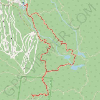
Round Top and Spruce Lake Loop
- Distance: 7.0 Km
- Elevation gain: 428 m
- Maximum elevation: 944 m
- Elevation loss: 427 m
- Minimum elevation: 521 m
Interactive map
GPS track profile
About this GPS track
Name: Round Top and Spruce Lake Loop GPS track, route, trail
Start: 582, Chemin Réal, Sutton, Brome-Missisquoi, Estrie, Québec, J0E 1B0, Canada (45.09691 -72.54888)
End: 582, Chemin Réal, Sutton, Brome-Missisquoi, Estrie, Québec, J0E 1B0, Canada (45.09687 -72.54885)
Coordinates: 45.08088 -72.54888 45.09719 -72.53597
Other GPS tracks
Click on a GPS track to view route, its statistics and profile.
Round Top - Sutton Trail
Canada > Quebec > Brome-Missisquoi > Sutton
https://en-hk.gps-viewer.com/track-hk4mt/Round-Top-Sutton-Trail/
Distance: 6.1 Km • Elevation gain: 422 m • Maximum elevation: 944 m