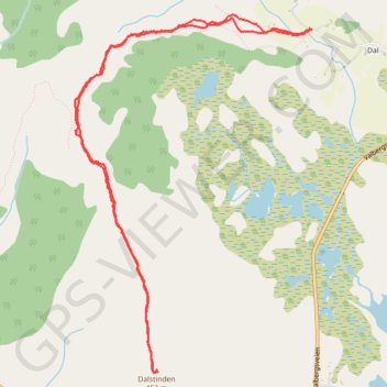
Dalstinden
- Distance: 6.0 Km
- Elevation gain: 464 m
- Maximum elevation: 439 m
- Elevation loss: 464 m
- Minimum elevation: 19 m
- Moving time: 2 h 9 m
- Moving speed: 2.8 Km/h
- Maximum speed: 11.8 Km/h
- Total time: 4 h 2 m
- Global speed: 1.5 Km/h
- Date: 08/07/14
Interactive map
GPS track profile
About this GPS track
Name: Dalstinden GPS track, route, trail
Start: Dalsveien, Dal, Vestvågøy, Nordland, Norvège (68.21170 14.03565)
End: Dalsveien, Dal, Vestvågøy, Nordland, Norvège (68.21173 14.03574)
Coordinates: 68.19692 14.00813 68.21238 14.03574
Other GPS tracks
Click on a GPS track to view route, its statistics and profile.
Stage 1: Arctic Ocean to Väylä — European Divide Trail
Distance: 2,785.0 Km • Elevation gain: 23,823 m • Maximum elevation: 722 m
Vikjord-Brustranda
Distance: 16.8 Km • Elevation gain: 992 m • Maximum elevation: 529 m