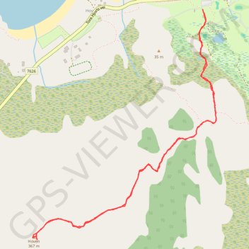
Hov
- Distance: 3.7 Km
- Elevation gain: 385 m
- Maximum elevation: 331 m
- Elevation loss: 384 m
- Minimum elevation: 8 m
- Moving time: 1 h 6 m
- Moving speed: 3.3 Km/h
- Maximum speed: 9.0 Km/h
- Total time: 1 h 22 m
- Global speed: 2.7 Km/h
- Date: 08/06/14
Interactive map
GPS track profile
About this GPS track
Name: Hov GPS track, route, trail
Start: Tore Hjorts vei, Hov, Vågan, Nordland, 8314, Norvège (68.33976 14.12446)
End: Tore Hjorts vei, Hov, Vågan, Nordland, 8314, Norvège (68.33967 14.12461)
Coordinates: 68.33043 14.10567 68.33981 14.12593
Other GPS tracks
Click on a GPS track to view route, its statistics and profile.
Stage 1: Arctic Ocean to Väylä — European Divide Trail
Distance: 2,785.0 Km • Elevation gain: 23,823 m • Maximum elevation: 722 m
LOF_31_hoven
Distance: 3.8 Km • Elevation gain: 356 m • Maximum elevation: 310 m