Xterra Poland 2016 Bike
En boucle depuis Kraków. #Boucle
- Distance: 18.3 Km
- Elevation gain: 242 m
- Maximum elevation: 238 m
- Elevation loss: 242 m
- Minimum elevation: 204 m
- Moving time: 1 h 54 m
- Moving speed: 9.6 Km/h
- Maximum speed: 12.3 Km/h
- Total time: 1 h 54 m
- Global speed: 9.6 Km/h
- Date: 01/01/10
Interactive map
GPS track profile
About this GPS track
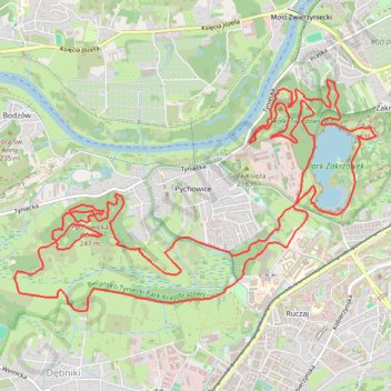
Name: Xterra Poland 2016 Bike GPS track, route, trail
Start: 22, Wyłom, Zakrzówek, Dębniki, Cracovie, Petite-Pologne, 30-364, Pologne (50.03547 19.91336)
End: 22, Wyłom, Zakrzówek, Dębniki, Cracovie, Petite-Pologne, 30-364, Pologne (50.03547 19.91337)
Coordinates: 50.02506 19.87084 50.04366 19.91601
Other GPS tracks
Click on a GPS track to view route, its statistics and profile.
Tour d'Europe
France > Bretagne > Finistère > Concarneau > Landan Creis
Distance: 7,132.9 Km • Elevation gain: 44,603 m • Maximum elevation: 2,433 m
Xterra Poland 2016. Bike pratI-Zakrzowek
Pologne > Petite-Pologne > Cracovie
En boucle depuis Kraków. #Boucle
Distance: 7.5 Km • Elevation gain: 103 m • Maximum elevation: 226 m
XTerra Poland CAP
Pologne > Petite-Pologne > Cracovie
En boucle depuis Kraków. #Boucle
Distance: 3.0 Km • Elevation gain: 29 m • Maximum elevation: 216 m