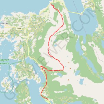
GT_Austvagoya_Etape1
- Distance: 12.8 Km
- Elevation gain: 989 m
- Maximum elevation: 758 m
- Elevation loss: 991 m
- Minimum elevation: 9 m
- Moving time: 3 h 8 m
- Moving speed: 4.1 Km/h
- Maximum speed: 54.5 Km/h
- Total time: 5 h 39 m
- Global speed: 2.3 Km/h
- Date: 20/05/14
Interactive map
GPS track profile
About this GPS track
Name: GT_Austvagoya_Etape1 GPS track, route, trail
Start: Hike, Midnattsolveien, Straumnes, Delp, Vågan, Nordland, 8315, Norvège (68.40104 14.50282)
End: Sandsletta Camping, Midnattsolveien, Sandsletta, Vågan, Nordland, 8315, Norvège (68.33607 14.49848)
Coordinates: 68.33607 14.48449 68.40109 14.52664
Other GPS tracks
Click on a GPS track to view route, its statistics and profile.
Stage 1: Arctic Ocean to Väylä — European Divide Trail
Distance: 2,785.0 Km • Elevation gain: 23,823 m • Maximum elevation: 722 m
Matmora 001
Distance: 13.4 Km • Elevation gain: 1,077 m • Maximum elevation: 764 m
GT_Austvagoya_Etape2
Distance: 13.1 Km • Elevation gain: 712 m • Maximum elevation: 515 m