Randonnée Buns
Randonnée en aller-retour depuis Moskenes. #Randonnée
- Distance: 34.4 Km
- Elevation gain: 865 m
- Maximum elevation: 306 m
- Elevation loss: 865 m
- Minimum elevation: 0 m
- Moving time: 6 h 56 m
- Moving speed: 5.0 Km/h
- Maximum speed: 32.8 Km/h
- Total time: 10 h 48 m
- Global speed: 3.2 Km/h
- Date: 21/07/15
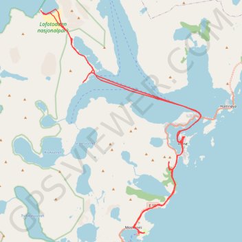
Interactive map
GPS track profile
About this GPS track
Name: Randonnée Buns GPS track, route, trail
Start: Moskenes Camping, Birger Eriksens vei, Moskenes, Nordland, 8392, Norvège (67.90041 13.05245)
End: Moskenes Camping, Birger Eriksens vei, Moskenes, Nordland, 8392, Norvège (67.90025 13.05172)
Coordinates: 67.90023 12.95285 67.98102 13.10691
Other GPS tracks
Click on a GPS track to view route, its statistics and profile.
Stage 1: Arctic Ocean to Väylä — European Divide Trail
Distance: 2,785.0 Km • Elevation gain: 23,823 m • Maximum elevation: 722 m
LOF_07_reinebriggen
Distance: 6.0 Km • Elevation gain: 522 m • Maximum elevation: 451 m
Munkan 001
Distance: 13.1 Km • Elevation gain: 975 m • Maximum elevation: 757 m
Reinebringen 001 002 001 001
Distance: 2.2 Km • Elevation gain: 493 m • Maximum elevation: 447 m
LOF_04_munkebu
Distance: 9.8 Km • Elevation gain: 645 m • Maximum elevation: 486 m
Bivouac dans les Lofoten - Ascension du Veinestinden
Ascension du Veinestinden et descente par le Reinebringen via son arête acérée. Plus d'informations : https://www.sentiersduphoenix.be/bivouac-lofoten-soleil-de-minuit/
Distance: 10.3 Km • Elevation gain: 1,240 m • Maximum elevation: 711 m
Munkebu-Hermannsdalstinden-Moskenes
Randonnée pédestre. #Randonnée
Distance: 15.8 Km • Elevation gain: 1,507 m • Maximum elevation: 1,029 m
GT_Moskenesoya_Etape10
Distance: 13.4 Km • Elevation gain: 793 m • Maximum elevation: 757 m
Munkebu-Hermannsdalstinden-Moskenes
Distance: 6.2 Km • Elevation gain: 842 m • Maximum elevation: 757 m