LOF_07_reinebriggen
- Distance: 6.0 Km
- Elevation gain: 522 m
- Maximum elevation: 451 m
- Elevation loss: 522 m
- Minimum elevation: 0 m
Interactive map
GPS track profile
About this GPS track
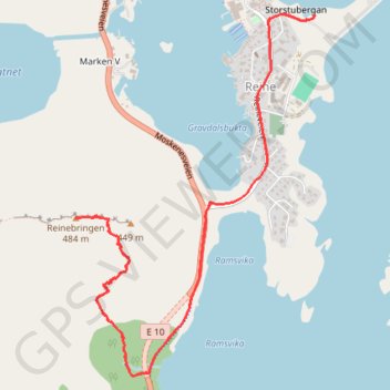
Name: LOF_07_reinebriggen GPS track, route, trail
Start: Reine ytre havn, Reine, Moskenes, Nordland, 8390, Norvège (67.93498 13.09389)
End: Reine ytre havn, Reine, Moskenes, Nordland, 8390, Norvège (67.93497 13.09392)
Coordinates: 67.92226 13.07141 67.93501 13.09392
Other GPS tracks
Click on a GPS track to view route, its statistics and profile.
Stage 1: Arctic Ocean to Väylä — European Divide Trail
Distance: 2,785.0 Km • Elevation gain: 23,823 m • Maximum elevation: 722 m
Reinebringen 001 002 001 001
Distance: 2.2 Km • Elevation gain: 493 m • Maximum elevation: 447 m
Bivouac dans les Lofoten - Ascension du Veinestinden
Ascension du Veinestinden et descente par le Reinebringen via son arête acérée. Plus d'informations : https://www.sentiersduphoenix.be/bivouac-lofoten-soleil-de-minuit/
Distance: 10.3 Km • Elevation gain: 1,240 m • Maximum elevation: 711 m
Randonnée Buns
Randonnée en aller-retour depuis Moskenes. #Randonnée
Distance: 34.4 Km • Elevation gain: 865 m • Maximum elevation: 306 m