Tuart trails
- Distance: 5.8 Km
- Elevation gain: 40 m
- Maximum elevation: 33 m
- Elevation loss: 39 m
- Minimum elevation: 13 m
- Moving time: 1 h 14 m
- Moving speed: 4.7 Km/h
- Maximum speed: 14.6 Km/h
- Total time: 1 h 16 m
- Global speed: 4.6 Km/h
- Date: 13/04/24
Interactive map
GPS track profile
About this GPS track
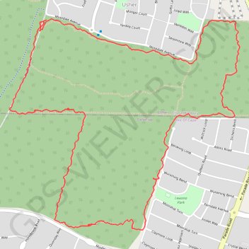
Name: Tuart trails GPS track, route, trail
Start: Ocean Drive, Usher, Bunbury, City Of Bunbury, Western Australia, Australia (-33.38100 115.62282)
End: Ocean Drive, Usher, Bunbury, City Of Bunbury, Western Australia, Australia (-33.38113 115.62269)
Coordinates: -33.39147 115.62061 -33.38095 115.63437
Topography: Bunbury topographic map
Other GPS tracks
Click on a GPS track to view route, its statistics and profile.
Bunbury MTB ride
Australia > Western Australia > Bunbury
Le Tour de Bunbury
Distance: 41.0 Km • Elevation gain: 400 m • Maximum elevation: 39 m
Tuart trails
Australia > Western Australia > Bunbury
Distance: 2.3 Km • Elevation gain: 16 m • Maximum elevation: 32 m
Tuart trails
Australia > Western Australia > Bunbury
Distance: 2.9 Km • Elevation gain: 19 m • Maximum elevation: 30 m