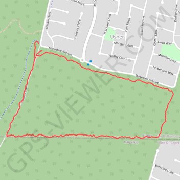
Tuart trails
- Distance: 2.9 Km
- Elevation gain: 19 m
- Maximum elevation: 30 m
- Elevation loss: 19 m
- Minimum elevation: 14 m
- Moving time: 37 m 33 s
- Moving speed: 4.7 Km/h
- Maximum speed: 12.0 Km/h
- Total time: 37 m 33 s
- Global speed: 4.7 Km/h
- Date: 01/04/24
Interactive map
GPS track profile
About this GPS track
Name: Tuart trails GPS track, route, trail
Coordinates: -33.38576 115.62060 -33.38048 115.63144
Topography: Bunbury topographic map
Other GPS tracks
Click on a GPS track to view route, its statistics and profile.
Tuart trails
Australia > Western Australia > Bunbury
Distance: 5.8 Km • Elevation gain: 40 m • Maximum elevation: 33 m