Dandenong Ranges National Park Loop
Interactive map
GPS track profile
About this GPS track
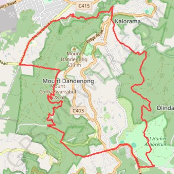
Name: Dandenong Ranges National Park Loop GPS track, route, trail
Coordinates: -37.86053 145.33360 -37.81526 145.38186
Topography: Melbourne topographic map
Other GPS tracks
Click on a GPS track to view route, its statistics and profile.
Upper Ferntree Gully
Australia > Victoria > Melbourne
Upftg ride
Distance: 44.0 Km • Elevation gain: 1,583 m • Maximum elevation: 529 m
Ferny Creek ride
Australia > Victoria > Melbourne
Distance: 36.9 Km • Elevation gain: 960 m • Maximum elevation: 531 m
Dandenong ranges botanical gardens
Australia > Victoria > Melbourne
Distance: 6.5 Km • Elevation gain: 228 m • Maximum elevation: 596 m
Morning MTB ride
Australia > Victoria > Melbourne
Morning Mountain Bike Ride
Distance: 35.8 Km • Elevation gain: 1,406 m • Maximum elevation: 549 m
Secret Garden, Dandenong Ranges Botanic, Pirianda
Australia > Victoria > Melbourne
Distance: 14.9 Km • Elevation gain: 459 m • Maximum elevation: 589 m
Dandenong ranges botanical garden
Australia > Victoria > Melbourne
Distance: 9.2 Km • Elevation gain: 132 m • Maximum elevation: 595 m
Secret Garden, Dandenong Ranges Botanic Garden
Australia > Victoria > Melbourne
Distance: 13.5 Km • Elevation gain: 321 m • Maximum elevation: 594 m