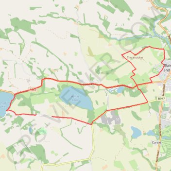
The Knockie, Marlee Loch and Loch of Clunie Loop
Loop MTB / run / hike around Blairgowrie via The Knockie, Marlee Loch and Loch of Clunie. #Hike #Loop #Nature #Countryside #Lake
- Distance: 17.2 Km
- Elevation gain: 271 m
- Maximum elevation: 203 m
- Elevation loss: 282 m
- Minimum elevation: 49 m
- Moving time: 1 h 6 m
- Moving speed: 15.5 Km/h
- Maximum speed: 46.3 Km/h
- Total time: 1 h 7 m
- Global speed: 15.3 Km/h
- Date: 03/03/24
Interactive map
GPS track profile
About this GPS track
Name: The Knockie, Marlee Loch and Loch of Clunie Loop GPS track, route, trail
Start: Craigie, Perth and Kinross, Scotland, PH10 6RD, United Kingdom (56.57635 -3.41277)
Coordinates: 56.57362 -3.44044 56.59981 -3.34424
Other GPS tracks
Click on a GPS track to view route, its statistics and profile.
North of Loch of Clunie
United Kingdom > Scotland > Perth and Kinross > Clunie
UK, Perthshire, Clunie
Distance: 12.2 Km • Elevation gain: 260 m • Maximum elevation: 189 m
Route to Plymouth
Royaume-Uni > Écosse > Highland > John o' Groats
Distance: 1,841.3 Km • Elevation gain: 25,233 m • Maximum elevation: 778 m
Around Newtyle Hill near Dunkeld
United Kingdom > Scotland > Perth and Kinross > Clunie
Distance: 24.4 Km • Elevation gain: 594 m • Maximum elevation: 278 m
Around Clunie, Perthshire
United Kingdom > Scotland > Perth and Kinross > Clunie
UK, Perthshire, Blairgowrie
Distance: 7.4 Km • Elevation gain: 152 m • Maximum elevation: 188 m
Around Clunie, Perthshire
United Kingdom > Scotland > Perth and Kinross
Afternoon Workout. UK, Perthshire, Blairgowrie
Distance: 16.4 Km • Elevation gain: 309 m • Maximum elevation: 187 m
Around Blairgowrie, Scotland
United Kingdom > Scotland > Perth and Kinross > Craigie
UK, Perthshire, Blairgowrie
Distance: 19.6 Km • Elevation gain: 174 m • Maximum elevation: 81 m