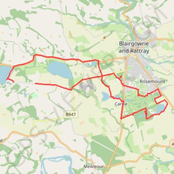
Around Blairgowrie, Scotland
Loop bike around Blairgowrie, Marlee Loch, Loch of Clunie, White Loch, Rosemount Golf Course and Stormont Loch. #Bike #Loop #Nature #Lake #Countryside #Forest
- Distance: 22.8 Km
- Elevation gain: 174 m
- Maximum elevation: 102 m
- Elevation loss: 192 m
- Minimum elevation: 46 m
- Moving time: 1 h 43 m
- Moving speed: 13.2 Km/h
- Maximum speed: 35.0 Km/h
- Total time: 2 h 11 s
- Global speed: 11.4 Km/h
- Date: 08/03/24
Interactive map
GPS track profile
About this GPS track
Name: Around Blairgowrie, Scotland GPS track, route, trail
Start: Craigie, Perth and Kinross, Scotland, PH10 6RD, United Kingdom (56.57664 -3.41737)
End: Craigie, Perth and Kinross, Scotland, PH10 6RD, United Kingdom (56.57701 -3.43456)
Coordinates: 56.56083 -3.44046 56.58913 -3.31184
Other GPS tracks
Click on a GPS track to view route, its statistics and profile.
The Knockie, Marlee Loch and Loch of Clunie Loop
United Kingdom > Scotland > Perth and Kinross > Craigie
Loop MTB / run / hike around Blairgowrie via The Knockie, Marlee Loch and Loch of Clunie. #Hike #Loop #Nature #Countryside #Lake
Distance: 17.2 Km • Elevation gain: 271 m • Maximum elevation: 203 m