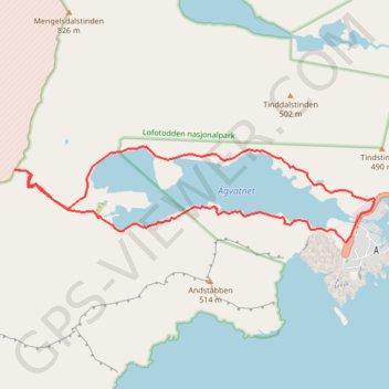
Trace
- Distance: 8.7 Km
- Elevation gain: 526 m
- Maximum elevation: 390 m
- Elevation loss: 525 m
- Minimum elevation: 3 m
Interactive map
GPS track profile
About this GPS track
Name: Trace GPS track, route, trail
Start: E 10, Å-gården, Å, Moskenes, Nordland, 8392, Norvège (67.88021 12.97745)
End: E 10, Å-gården, Å, Moskenes, Nordland, 8392, Norvège (67.88027 12.97751)
Coordinates: 67.88021 12.90490 67.88816 12.98367
Other GPS tracks
Click on a GPS track to view route, its statistics and profile.
Stage 1: Arctic Ocean to Väylä — European Divide Trail
Distance: 2,785.0 Km • Elevation gain: 23,823 m • Maximum elevation: 722 m
Stokkvika north and south bank
Distance: 13.2 Km • Elevation gain: 966 m • Maximum elevation: 412 m
GT_Moskenesoya_Etape10
Distance: 13.4 Km • Elevation gain: 793 m • Maximum elevation: 757 m
GT_Moskenesoya_Etape11
Distance: 12.6 Km • Elevation gain: 942 m • Maximum elevation: 412 m