GT_Moskenesoya_Etape11
- Distance: 12.6 Km
- Elevation gain: 942 m
- Maximum elevation: 412 m
- Elevation loss: 951 m
- Minimum elevation: 2 m
Interactive map
GPS track profile
About this GPS track
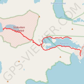
Name: GT_Moskenesoya_Etape11 GPS track, route, trail
Start: Djuplia, Å, Moskenes, Nordland, 8392, Norvège (67.88685 12.96434)
End: 64, Langhaugan, Å-gården, Sørvågen, Moskenes, Nordland, 8392, Norvège (67.87736 12.97782)
Coordinates: 67.87736 12.86398 67.89288 12.97782
Other GPS tracks
Click on a GPS track to view route, its statistics and profile.
Stage 1: Arctic Ocean to Väylä — European Divide Trail
Distance: 2,785.0 Km • Elevation gain: 23,823 m • Maximum elevation: 722 m
Stokkvika north and south bank
Distance: 13.2 Km • Elevation gain: 966 m • Maximum elevation: 412 m
Munkebu-Hermannsdalstinden-Moskenes
Randonnée pédestre. #Randonnée
Distance: 15.8 Km • Elevation gain: 1,507 m • Maximum elevation: 1,029 m
GT_Moskenesoya_Etape10
Distance: 13.4 Km • Elevation gain: 793 m • Maximum elevation: 757 m