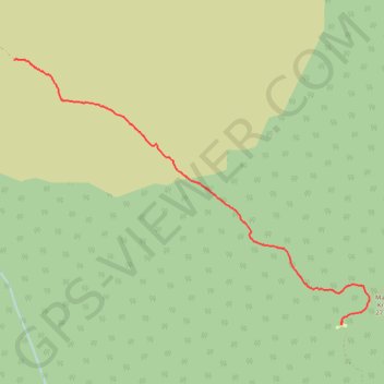
2017-09-28_10-33-13
En aller simple.
- Distance: 8.1 Km
- Elevation gain: 8 m
- Maximum elevation: 3,442 m
- Elevation loss: 736 m
- Minimum elevation: 2,706 m
- Moving time: 1 h 43 m
- Moving speed: 4.7 Km/h
- Maximum speed: 9.3 Km/h
- Total time: 1 h 59 m
- Global speed: 4.0 Km/h
- Date: 28/09/17
Interactive map
GPS track profile
About this GPS track
Name: 2017-09-28_10-33-13 GPS track, route, trail
Start: Rombo, Kilimandjaro, Northern Zone, Tanzanie (-3.14606 37.46931)
End: Mandara Huts, Rombo, Kilimandjaro, Northern Zone, Tanzanie (-3.18126 37.51338)
Coordinates: -3.18160 37.46931 -3.14592 37.51711
Other GPS tracks
Click on a GPS track to view route, its statistics and profile.
2017-09-28_13-27-33
En aller simple.
Distance: 8.1 Km • Elevation gain: 5 m • Maximum elevation: 2,709 m